| |
|
Maritime
Lanka
|
18 Dec 2004
|
|||
| Last modified: 18 Dec 2004 |
 |
 |
 |
 |
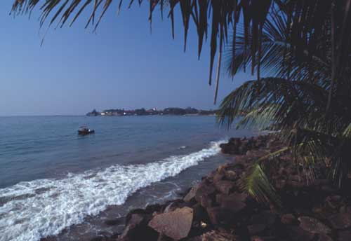
The Avondster (site L) lies in the heart of Galle harbour, close to the rocky shore of Marine Drive, near the market. The photograph shows a boat above the site, with Galle fort in the distance. Conditions are not always so benign: a fishing boat was recently wrecked at the same spot.
Contemporary records mention that the Avondster sank in the mouth of a river. In an irritated report naming all those who might be held responsible, the VOC's officials recorded:
' the old yacht Avondster in Gallons Bay, after slipping her anchor rope because of bad supervision was wrecked struck ground and broke immediately in front of the garden of Marcus Lasseres, and the outcoming river on the side of the mountain.'
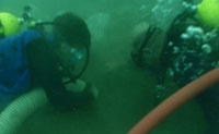
Today rivers have been channelled into storm drains, and there are some drawbacks to the Avondster's convenient location. Before she was positively identified, she was known to the diving team as 'the chicken's foot wreck'. Visibility is sometimes close to zero, but varies with the swell, and many a tale can be told about the bizarre assortment of objects found on the site, in front of the divers' masks, or wrapped around a mouthpiece.
The partially buried wreck lies in 5 metres of water, on a gently shelving sea bed composed of sand and finer sediments covered by organic detritus. During monsoons, fresh water flows directly into the harbour, and the salinity of the harbour water is relatively low. Layers of fresh water on the surface have also been noted after heavy rain. In the mid-seventeenth century when the Avondster was wrecked, two rivers flowed directly into the Bay of Galle. Fresh water inflows of such magnitude would have significantly slowed degradation - but the rivers near the wreck site no longer flow.
Prior to excavation, there was no immediate evidence of human disturbance on this site. However, given the readily accessible location, it is likely that exposed artefacts have been recovered. Local antique shops offer an interesting range of ceramics from the Dutch period, some of which have probably come from wrecks. The poor visibility on the site, and the sediments which rapidly obscure it further when disturbed, may however have protected the site from serious looting. The historical records indicate that the Avondster sank rapidly in fine silt, and no significant salvage attempt was made at the time.
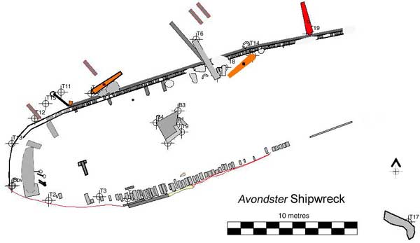
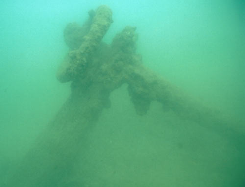
The ship's remains cover an area about 40m long and 10m wide. The bow lies towards the south-west, and the stern towards the north-east. The shape of the hull is outlined, with timber frames and planking protruding on average 50cm above the sea bed. (The extent of exposure had been increasing year-by-year, and the timbers most exposed were eroding at a similar pace, until protective sandbags were laid in 1999.) A section of the stern is broken away from the main wreckage - corresponding with contemporary accounts of the ship breaking in two - and protrudes 2-2.5m above the seabed, with significant scouring. The centre of the site is almost entirely covered with sand, with two large deck support timbers protruding from the port side. The ship settled on the seabed listing 30° to starboard, so five of the six cannon are found on that side.
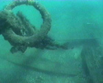 Divers often followed the anchor to find the hull: this was the view on an unusually clear day. |
 The wooden anchor stock. |
Near the bow on the starboard side was a large anchor shank of wrought iron, projecting at an angle from the seabed, and ending in a complete anchor ring about three metres below the surface. The anchor remained solid until being raised in 2002. In 1993, half of the original wooden anchor stock was still visible, and the pattern of erosion suggested that it had only recently been exposed. By 1996, the surviving portion had halved in length, and by 1997 it was gone. The anchor stock was of Asian wood; repairs would frequently be made with locally available materials.
There are several iron cannon visible on the starboard side. One of the test excavation pits contained possible evidence of gun port, gun carriage, and rope tackle in association.
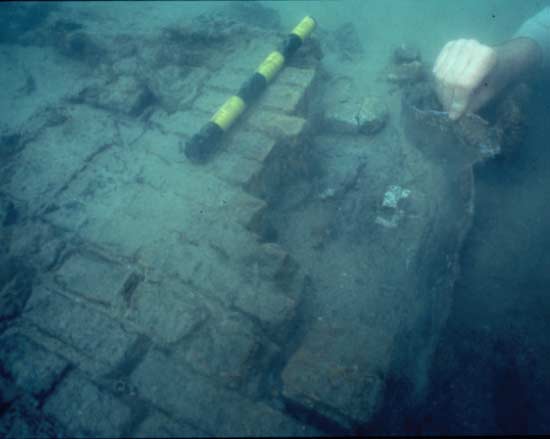
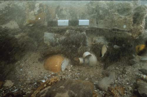
 Amidships,
the galley rises clear of the seabed, in the form of a large assemblage of yellow
Dutch bricks (overijselsteen), cemented together, with a surround of
lead sheeting, visible in the picture on the left. The hearth and some of the
brick walls survive. In the photo on the right, a large barrel is visible on
the left of the picture.
Amidships,
the galley rises clear of the seabed, in the form of a large assemblage of yellow
Dutch bricks (overijselsteen), cemented together, with a surround of
lead sheeting, visible in the picture on the left. The hearth and some of the
brick walls survive. In the photo on the right, a large barrel is visible on
the left of the picture.
A later section discusses galleys on 17th century ships; for a detailed description of the galley site, see 1997 examination of galley remains.
The hull has three layers of planking, and is expected to shed new light on the building technique known as 'double-planking plus sheeting', which may have been an adaptation for Asia. Between the hull and at least one deck there are hanging knees, evidence of the ship's English origin.
The buried hull remains have been protected by the sediment, and are generally in sound condition despite more than three hundred years of immersion. Exposed sections of the wreck, on the other hand, are slowly being destroyed. Physical damage is a greater danger than biological activity, and arises both from wave action and from harbour activity. The wrecked fishing boat was dragged through the site during salvage efforts.
| Maritime Lanka homepage | Areas of the Avondster |