|
Maritime
Lanka |
26 Jan 2003
|
|||
| Last modified: 26 Jan 2003 |
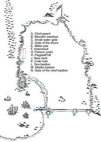
The original description of 'N' was 'De punct staende achter de Hoofdwacht', which should be translated 'the bastion which stands behind the chief guard'. Van Goens refers to this map in a 1660 submission to Batavia about proposed improvements to the fortifications, which he would start meanwhile. For example, the height of the wall between the middle bastion and the sea bastion was only 9-13 feet, which he considered insufficient. The Governor-General in Batavia did not agree, and most of the improvements were temporarily halted, but the walls were already being raised and the moat deepened, and this work continued.
| Maritime Lanka homepage |